Studio Orange has provided two maps for Noman’s Land in Trigun Stampede (2023).
Seven Cities Union Map
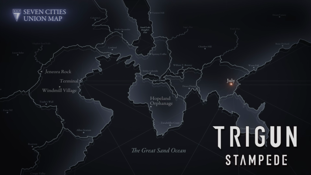
The Seven Cities Union Map is the official map used as the bumpers (in Japan, these are called eyecatch (アイキャッチ, aikyatchi) — thanks to schakerin for the term!).

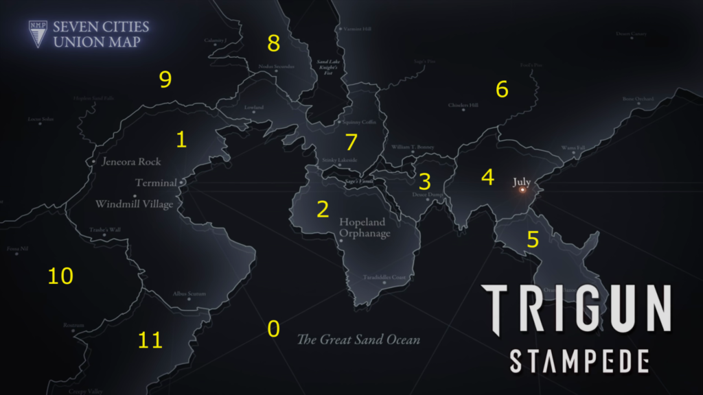
This map highlights the points visited during the first season of Trigun Stampede and contains the following geographic information:
This area of the planet is divided into regions that may correspond with political divisions such as city-states or counties, depending on the political structure of human society. Despite the title of the map, we only see one of the Seven Cities: JuLai (labeled July).

Region 0
Region 0 is featured in “Once Upon A Time In Hopeland” and “WOLFWOOD“. It consists of The Great Sand Ocean, which covers a large portion of the lower right and center of the map. Vash takes the Sand Steamer from the western “coast” Terminal, with intent to sail around Regions 2 and 5, landing at July. After picking up Vash and company, SEEDS03 travels over the eastern part of the Great Sand Ocean and drops Vash and Wolfwood in Region 4 in pursuit of the kidnapped Meryl and Roberto.
Region 1
Region 1 is featured in the first six episodes. Jeneora Rock is shown in “NOMAN’S LAND“, “The Running Man“, and “Bright Light, Shine Through the Darkness“. “HUNGRY!” takes place in the empty desert between Jeneora Rock and the Windmill Village. “Child of Blessing” takes place in the Windmill Village. “Once Upon A Time In Hopeland” features the Sand Steamer terminal.
Two unvisited locations are also shown for Region 1. South of the Windmill Village is Trashe’s Wall. At the far south of Region 1 is Albus Scutum — Latin for “white shield,” possibly describing an area of exposed white bedrock.
Region 2
Region 2 is a relatively isolate geographic section, surrounded by the Great Sand Ocean to the west, south, and east, and connected to Regions 7 and 3 by narrow land bridges on each side of the wide sand lake Sage’s Vomit. It is featured in “WOLFWOOD” as the destination for the runaway Sand Steamer, and the meeting point for Vash and SEEDS03.
One unvisited location is shown for Region 2. At the far south is Taradiddle’s Coast.
Region 3
Region 3 is not shown in Trigun Stampede. It is located between Region 2 and Region 4. An unvisited location is shown. Deuce Dump is located along the center south coast.
Region 4
Region 4 is featured in flashback in “Our Home” and “Millions Knives, and in present day in “Humanity“, “To a New World“, and “High Noon at July“. The only location shown or marked is JuLai (spelled July). As of the events of “High Noon at July“, the city of JuLai has been obliterated.
Region 5
Region 5 is a peninsula surrounded by the Great Sand Ocean, and connected at the northwest to Region 4. One unvisited location is shown, Orange Kazoo.
Region 6
Region 6 is a large, thinly populated area to the north of Regions 3 and 4. There are two large dry rivers, Sage’s Piss and Fool’s Piss. At the far east, there is a location at the coast of the Great Sand Ocean, Wams Falls, and further north along the coast is the location Bone Orchard. In the far north away from the coast is the location Desert Canary. In the center of the region is Chiseler’s Hill. In the southwest, just above Region 3, is the location William T. Bonney. In the far west, along Sand Lake Knight’s Fist, is the location Varmint’s Hill.
Region 7
Region 7 consists of two large areas separated by a narrow land bridge, with the Great Sand Ocean to the southwest and an unmarked sand lake to the northeast. In the northwest region is one location, Lowland. In the southeast region are two locations, Stinky Lakeside, on the coast of Sage’s Vomit sand lake, and Squinney Coffin, on the coast of the unmarked sand lake.
Region 8
Region 8 is bordered on the east by Sand Lake Knight’s Fist. There is one location Nodus Seconds — Latin for “The Second Knot.”
Region 9
Region 8 is another large area. At the eastern border with Region 9 is the location Calamity J. Further south is the dry river Hopeless Sand Falls. To the far west is the location Locus Solus — Latin for “only place.”
Region 10
In the north of Region 10 is the location Fossa Nil — Latin for “empty ditch.” In the southeast at the border with Region 11 is the location Rostrum — Latin for “face.”
Region 11
Region 11 has one location in at the far south, Creepy Valley.
SakuraCon2023 Map
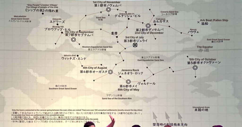
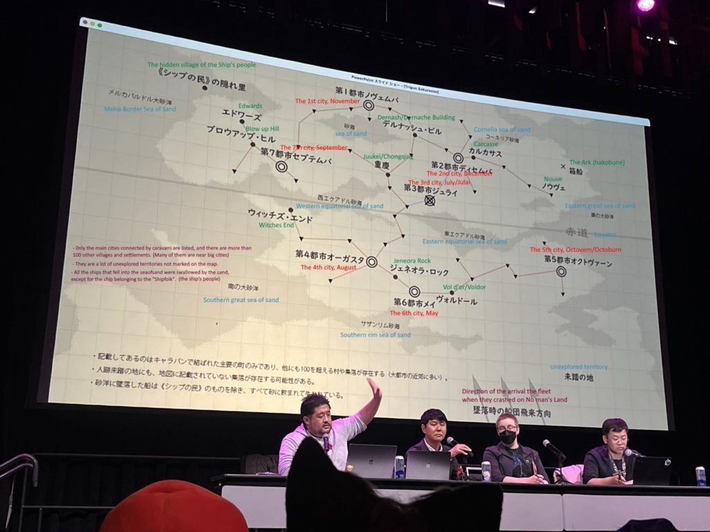
This map was revealed at the SakuraCon2023 anime convention. This map shows a wider view of No Man’s Land.
While the geography of the SakuraCon2023 map and the Seven Cities Union Map are not exactly aligned, both were provided by Studio Orange, and Jeneora Rock and the destroyed JuLai are in similar proximity in both maps.
If this map is more “correct” than the Seven Cities Union Map, then the Seven Cities Union Map should actually be oriented 90 degrees counter-clockwise to correctly orient Jeneora Rock and JuLai, with JuLai to the north. However, it was stated in “Bright Light, Shine Through the Darkness” that the journey from Jenora Rock to JuLai runs east. Future official maps may provide clarification.


Map Notes
The translated text at the bottom of the map reads:
“Only the towns connected to the caravan going between the main cities are noted/There are over 100 unmarked settlements (mostly around big cities).” Based on this, the arrowed lines between locations appear to be caravan routes.
“It’s possible that there are settlements in the unexplored areas.”
“Excluding the “Ship People,” all ships that fell into the sand ocean have been swallowed up by the sands.” The Ship People likely refers to SEEDS03, and indicates that they have a hidden village where the ship resides when not traveling.
Next to the three arrows: “Direction of the arrival of the fleet when they crashed on Noman’s Land.”
The planet’s equator goes through the center of the map.
The following locations are marked:
Sand Seas/Oceans
There are eight marked regions of sand seas or oceans. All the sands are connected apart from the Sand Sea in the north, which is surrounded by habitable land.
- Northwest: Melca Border Great Sand Ocean
- Southwest: Southern Great Sand Ocean
- South: Sand Sea of the Southern Rim
- East: Eastern Great Sand Ocean
- Northeast: Cornelia Sea of Sand
- North: Sand Sea
- Center-West: Western Equatorial Sand Sea
- Center-East: Eastern Equatorial Sand Sea
The Seven Cities and Other Settlements
All seven cities are shown on the map. Several surrounding towns and villages are marked. A region of unexplored territory is marked at the bottom right corner of the map.
- 1st City of November
- Dernash Building
- 2nd City of December
- Juukei/Chongqing
- Carcasse
- Nouve
- The Ark Boat/Fallen Ship (landing site for Knives’ Ark post-JuLai?)
- 3rd City of JuLai
- 4th City of August
- Witches End
- 5th City of Octovern
- 6th City of May
- Jeneora Rock
- Voldor (or Vol D’or)
- 7th City of September
- Blow Up Hill
- Edwards
- Hidden Village of the Ship People (SEEDS03)